The blueprint to creating thriving green streets that increase foot traffic and trade
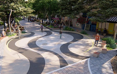
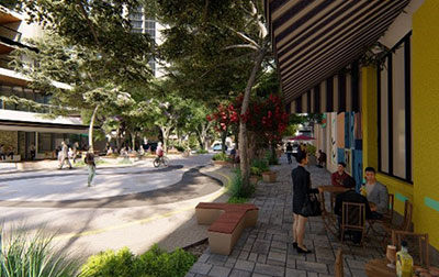
Currently, the street attracts little foot traffic and the residential and business ends are disparate. Trees are virtually non-existent, off-street parking is hard to find, and footpaths are narrow. The plan proposes landscaped verges, rain gardens, public alfresco seating areas, widened footpaths and crossings, traffic-calming measures, public artwork, new trees, and improved pedestrian accessibility and on-street parking bays.
We’re fortunate that the City of Melville has the leadership to drive projects like this with an integrated team beyond engineering. The council assembled a placemaking team that included planners and designers who, together with Hatch, could expertly develop a vision of how this space should look.
It’s important to note that Ogilvie Road is a test case—it is the first of several roads to be revitalized in the activity center, and offers a great example of what a street looks like when people and businesses come first.
How do we transform streets that prioritize people, local trade, and greenery?

There are effective and proven techniques to achieve this kind of outcome while mitigating the problems that projects like this typically encounter.
Address community concerns early
Often project planning can become highly politicized, attracting objections by community members. To mitigate this, planners should hold a walkshop: a public engagement session where all participants walk the site together and discuss the issues. They should also consult with the local community, businesses, and landowners throughout the concept and design process, tempering and moderating their concerns, and identifying their broader needs.
One of the key issues for the local community has been the height of new buildings within the Canning Bridge plan. In our consultation with community stakeholder groups, we found that the community agreed that what happens on the ground is as important as the height of a building. Focus groups, town halls, and surveys can be very effective. Showing the community how the enhancements will benefit them is important. In this case, we developed a video of the Ogilvie Road concept plan that demonstrates how it addresses community needs and concerns.
Calibrate land uses realistically
One area of urban planning that tends to be problematic in Australia is the calibration of land uses to streets. For instance, when redesigning urban streetscapes, planners tend to advocate for activated business frontages and little to no space between the building and property line. This only works for businesses that want to trade to the street; businesses such as offices and health centers will cover their exposed facades. We wanted the right activated frontages, not blank facades.
Widen footpaths to encourage pedestrians and alfresco dining
Footpaths contribute to the mental and physical wellbeing of residents by facilitating physical exercise, and community and social cohesion.[1] It can be challenging to hold a conversation on a narrow footpath with the constant need to fall into single file to allow oncoming pedestrians to pass. Wider footpaths strengthen existing social and cultural use by accommodating temporary recreation and commercial events such as markets and live music performances.[2] They can also allow bar and cafe patrons to sit outside, thereby extending trade into the public realm and providing opportunity for alfresco dining. Particularly appropriate for the Perth climate.
Add street furniture
Benches, streetlights, plant pots, and safety bollards facilitate a sociable, inclusive, and safe atmosphere in urban environments. Sitting places specifically foster rest and relaxation, encouraging pedestrians to enjoy their surroundings and spend more time in a certain vicinity. This is particularly pertinent to older members of the community and those with mobility issues, as it increases accessibility by providing resting places for them.

Substitute some street parking with “parklets”
Converting a few curb-side parking spaces into “parklets” that fuse street greenery and public seating spaces can boost local biodiversity and give pedestrians relief from the hustle and bustle of city living. More greenery can help with the absorption of rainwater run-off, which traps pollution, reduces flood risk, and cools the area. To ensure a comfortable and safe sitting environment, consideration should be given to street barriers, wind protection, and lines of sight. The Ogilvie Road concept plan replaced 20 per cent of parking bays with parklets, more trees, and seating areas—a move welcomed by local businesses.
Well considered signage, especially for off-street parking
Well placed street signs strengthen the legibility, navigation, cohesion, and accessibility of urban environments. They increase the utilisation of lesser-known places in a precinct—elements that smartphone maps don’t always identify. In the case of Ogilvie Road, distinct signage for off-street parking improves traffic flow through the area and frees space for pedestrians. In parallel, look for complementary opportunities to reduce street signs that don’t add visual clutter and don’t contribute to legibility.
Blend pedestrian paving with the street
Safely integrating vehicle lanes with pedestrian pavements improves aesthetic appeal and indicates to drivers that they are entering a different road environment.[3] Often curbs and gutters are removed to avoid ambiguity as to where pedestrians are permitted to walk and to reinforce their right of way. As shared zones allow pedestrian, cyclist, and vehicle movement, there should be a coordinated design approach to maintain pedestrian safety, including consideration of the placement of trees, furniture, lighting, and paving.
Introduce waterwise landscaping
Street greenery is essential to sustainable urban development as it improves mental and physical wellbeing for locals through increased air quality, shading, and beautification of metropolitan infrastructure. Effective waterwise landscaping groups plants by water needs—generally using water more efficiently—and has plantings that can tolerate drought.
To find out more about transforming urban spaces, contact us.
[1] Science Direct, https://www.sciencedirect.com/science/article/pii/S0264275121001293#bb0420
[2] Monash University Lens, 8 May 2019, https://lens.monash.edu/@design-architecture/2019/05/08/1374807/dont-forget-the-footpath-its-vital-public-space
[3] City of Sydney,
https://www.cityofsydney.nsw.gov.au/-/media/corporate/files/2020-07-migrated/files_s-3/sydneystreetscode2013-adopted-2400613-part4.pdf?download=true

Peter Ciemitis
Senior associate and lead urban designer, Urban Solutions
Peter is a senior associate and lead urban designer. He brings 40 years of detailed knowledge and acclaimed expertise in the design and delivery of TOD activity centres, urban infill, waterfronts, and residential development. His experience can be used widely used to find the most practical and commercial design solutions, or to introduce the wildest, most creative ideas. He brings an extra dimension through his passion and interest in arts and culture, creating places with an eye to preserving beauty as well as social and cultural meaning.